
Αρχείο:The map of the Holy Land by Marino Sanudo (drawn in 1320).jpg

Εικόνα σε υψηλότερη ανάλυση (1.950 × 1.272 εικονοστοιχεία, μέγεθος αρχείου: 1,07 MB, τύπος MIME: image/jpeg)
|
|
Αυτό το αρχείο και η περιγραφή του προέρχονται από το Wikimedia Commons. Οι πληροφορίες από την σελίδα περιγραφής του εκεί εμφανίζονται παρακάτω. |
Σύνοψη
| Περιγραφή |
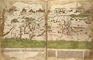
English: The map of the Holy Land by Marino Sanudo (drawn in 1320) Map orientation: north pointing left Latin text at bottom:[1] A: Tota terra a monte Libano per latus occidentale Jordanis vsque Capharnaum et inde per Saphet et Kabul et Toronum redeundo ad Libanum vocatur Yturea et Galilea superior et Galilea gentium et terra Kabul et terra Rob et saltus Libani et fuit pro magna parte de regione Decapoleos B: Tota terra a Tyberiade per Betsan et montem Effraym vsque Magedo et inde per capud Carmeli et montem Tabor et Betuliam vsque in Tyberiadem redeundo vocatur campus magnus Esdrelon vel campus Fabe, siue Magedo, vel Galilea inferior et planicies Galilee C: Tota terra a Cesarea Palestine vsque Joppen et inde transeundo per Tampnacsare et redeundo per Caco vsque Cesaream dicitur mons Effraym, licet sit terra campestris, et Saron, de quo dicitur Ysai. Factus est Saron sicut desertum, et est terra fertilis valde et pinguis habens villas multas et loca nemorosa et maxime circa Arsur suntque ibi leones multi et venationes regie E: Desertum Cades, vnde miserant filii Israel exploratores , qui post XL dies huc redierunt et murmurante populo jussi sunt redire in desertum per viam maris rubri et post XXX annos redierunt ad locum istum, vnde moventes castra contra orientem circuierunt montem Seyr et terram Amon et capta terra Seon, regis Osebon, et Og, regis Basan, venerunt ad Jordanem contra Jerico |
||
| Ημερομηνία | |||
| Πηγή |
Liber secretorum fidelium crucis by Marino Sanudo, c. 1321.
|
||
| Δημιουργός | Marino Sanuto the Elder (c. 1260 – 1338); Pietro Vesconte |

.jpg?uselang=el)
Αδειοδότηση
|
Το δισδιάστατο έργο τέχνης που απεικονίζεται σε αυτή την εικόνα είναι κοινό κτήμα (δηλαδή δεν καλύπτεται από πνευματικά δικαιώματα) παγκόσμια, εξαιτίας της ημερομηνίας θανάτου του δημιουργού του, ή της ημερομηνίας της έκδοσής του.
Συνεπώς και αυτή η αναπαραγωγή του έργου είναι κοινό κτήμα (αυτό ισχύει για αναπαραγωγές που δημιουργήθηκαν στις Ηνωμένες Πολιτείες, την Γερμανία, και πολλές άλλες χώρες).
| ||||
This media file is in the public domain in the United States. This applies to U.S. works where the copyright has expired, often because its first publication occurred prior to January 1, 1929, and if not then due to lack of notice or renewal. See this page for further explanation.
|
 | |
 |
This image might not be in the public domain outside of the United States; this especially applies in the countries and areas that do not apply the rule of the shorter term for US works, such as Canada, Mainland China (not Hong Kong or Macao), Germany, Mexico, and Switzerland. The creator and year of publication are essential information and must be provided. See Wikipedia:Public domain and Wikipedia:Copyrights for more details.
|
Ιστορικό αρχείου
Κλικάρετε σε μια ημερομηνία/ώρα για να δείτε το αρχείο όπως εμφανιζόταν εκείνη τη στιγμή.
| Ώρα/Ημερομ. | Μικρογραφία | Διαστάσεις | Χρήστης | Σχόλια | |
|---|---|---|---|---|---|
| τελευταία | 08:53, 8 Ιουλίου 2017 | | 1.950 × 1.272 (1,07 MB) | Onceinawhile | revert |
| 08:51, 8 Ιουλίου 2017 |  | 1.950 × 1.272 (1,07 MB) | Onceinawhile | cropped | |
| 08:41, 8 Ιουλίου 2017 |  | 2.000 × 1.408 (1,18 MB) | Onceinawhile | higher res | |
| 03:32, 6 Μαΐου 2011 |  | 545 × 247 (58 KB) | Geagea | == {{int:filedesc}} == {{Information |Description={{en|1=The map of the Holy Land by Marino Sanudo (drawn in 1320)}} |Source=[http://www.christusrex.org/www1/ofm/mad/articles/HarweyMaps.html www.christusrex.org] |Date=1320 |Author=[[:he::en:Marino Sa |
Συνδέσεις αρχείου
Τα παρακάτω λήμματα συνδέουν σε αυτό το αρχείο:
Καθολική χρήση αρχείου
Τα ακόλουθα άλλα wiki χρησιμοποιούν αυτό το αρχείο:
- Χρήση σε ar.wikipedia.org
- Χρήση σε arz.wikipedia.org
- Χρήση σε bn.wikipedia.org
- Χρήση σε ca.wikipedia.org
- Χρήση σε ckb.wikipedia.org
- Χρήση σε en.wikipedia.org
- Book of Joshua
- Israelites
- Holy Land
- Marino Sanuto the Elder
- History of cartography
- Historiography of the Crusades
- User:Onceinawhile
- Portal:Maps
- Cartography of Palestine
- Talk:Cartography of Palestine
- Template:Did you know nominations/Cartography of Palestine (region)
- Wikipedia:Recent additions/2020/April
- Wikipedia:Main Page history/2020 April 23
- Wikipedia:Did you know/Statistics/Monthly DYK pageview leaders/2020/April
- User:Mr. Ibrahem/map1
- Χρήση σε es.wikipedia.org
- Χρήση σε fa.wikipedia.org
- Χρήση σε fr.wikipedia.org
- Χρήση σε he.wikipedia.org
- Χρήση σε it.wikipedia.org
- Χρήση σε it.wikisource.org
- Χρήση σε ja.wikipedia.org
- Χρήση σε lmo.wikipedia.org
- Χρήση σε lt.wikipedia.org
- Χρήση σε nia.wikipedia.org
- Χρήση σε no.wikipedia.org
- Χρήση σε ro.wikipedia.org
- Χρήση σε sq.wikipedia.org
- Χρήση σε ta.wikipedia.org
- Χρήση σε vi.wikipedia.org
- Χρήση σε www.wikidata.org
.jpg)