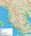
Αρχείο:Map of ancient Epirus and environs (English).svg

Τα περιεχόμενα της σελίδας δεν υποστηρίζονται σε άλλες γλώσσες.
Αυτό το αρχείο προέρχεται από το Wikimedia Commons
Από τη Βικιπαίδεια, την ελεύθερη εγκυκλοπαίδεια

Εικόνα σε υψηλότερη ανάλυση(Αρχείο SVG, ονομαστικό μέγεθος 1.303 × 1.500 εικονοστοιχεία, μέγεθος αρχείου: 495 KB)

Translate this file

Αυτό το αρχείο SVG περιέχει κείμενο που μπορεί εύκολα να μεταφραστεί χρησιμοποιώντας [toolforge:svgtranslate/File:Map_of_ancient_Epirus_and_environs_(English).svglink αυτό το αυτόματο εργαλείο]. Περισσότερα.

Σύνοψη

Περιγραφή
English: Map of ancient Epirus & Environs, Thracian, Illyrian, Paeonian, & Greek contact zones with illustration and extent of Hellenization up to the creation of Epirus Nova or Illyria Graeca
Ημερομηνία
Πηγή Έργο αυτού που το ανεβάζει
Δημιουργός MaryroseB54
άλλες εκδόσεις

[επεξεργασία]

  • The classical age of Greece (1999),
  • ed. Atlas of the Greek and Roman world in antiquity (1981).
  • Hammond, N. G. L. A History of Greece to 322 B.C., 1986, ISBN-10: 0198730950
  • Wilkes, J. J. The Illyrians, 1992,ISBN 0631198075, (i.e. pages 174, 208, 210, 273)
  • In the Shadow of Olympus: The Emergence of Macedon,ISBN 0691008809,1992
  • Thracian Tribal areas (from Fol, Thrace and the Thracians, p 133),The Thracians 700 BC–AD 46 (Men-at-Arms 360) by Christopher Webber After Hoddinot, Col & Cah
  • Hendry, p. 299. The geography is entirely correct for Servius' time, since Diocletian's rearrangement of provincial boundaries included the creation of the province of Epirus Nova out of southern Illyricum with Dyrrachium (=Epidamnus) as its capital.
  • The Loeb Editor's Notes, 28 Nova Epirus or Illyris Graeca (Epirus, Nova Illyria Graeca) "Nova Epirus or Illyris Graeca extended from the Drilo (Mod. Drina) River on the north to the Ceraunian Mts. on the south, thus comprising a large part of modern Albania. Immediately to the south of it to the Ambracian Gulf (Mod. Gulf of Arta) lay what is here called Old Epirus, approximately identical with the Epirus of modern Greece."
  • Soustal, Peter; Koder, Johannes (1981). Tabula Imperii Byzantini, Band 3: Nikopolis und Kephallenia (in German). Vienna: Verlag der Osterreichischen Akademie der Wissenschaften. ISBN 3-7001-0399-9., page 47
  • A new classical dictionary of Greek and Roman biography, mythology, and geography: partly based upon the Dictionary of Greek and Roman biography and mythology by Sir William Smith,1851,page 392 "B. Illyris Graeca, which was called in later times Epirus Nova, extended from the river Drilo to the SE., up to the Ceraunian mountains, which separated it from Epirus Proper"
  • American journal of philology, Τόμοι 98-99,by JSTOR (Organization), Project Muse,1977,page 263, the partly Hellenic and partly Hellenized Epirus Nova
  • Epirus Vetus: The Archaeology of a Late Antique Province (Duckworth Archaeology) by William Bowden,2003,ISBN-10: 0715631160,2003,page 233,of Lissos in Epirus Nova
  • Migrations and invasions in Greece and adjacent areas by Nicholas Geoffrey Lempriere Hammond,1976,ISBN -0815550472,page 54,The line of division between Illyricum and the Greek area Epirus nova
  • Athanassakis, A.N. (1977), "N.G.L. Hammond, Migrations and Invasions in Greece and Adjacent Areas (review)", American Journal of Philology 99: 263–6, JSTOR 293653
  • Hammond, N. G. L. A History of Greece to 322 B.C., 1986, ISBN-10: 0198730950
  • Triadafilopoulos, Triadafilos (November 2000). "Power politics and nationalist discourse in the struggle for 'Northern Epirus': 1919-1921". Journal of Southern Europe and the Balkans,
  • Encyclopedia Britannica,2002,ISBN -0852297874,The Roman province of Illyricum stretched from the Drilon River (the Drin, in modern Albania) in the south to Istria (modem Slovenia and Croatia)
  • History of the Byzantine Empire: Vol. 1, 324-1453 (Paperback) by Alexander A. Vasiliev
  • Epire, Illyrie, Macedoine: melanges offerts au professeur Pierre Cabanes by Daniele Berranger,Pierre Cabanes,Daniele Berranger-Auserve,page 130
  • In An Inventory of Archaic and Classical Poleis by Mogens Herman, ISBN 0-19-814099-1, 2004, i.e. "As a long-distance trading community, Aigina was not an active coloniser, but colonised Kydonia (no. 968) in 519, Adria (no. 75) c.C61, and Damastion in Illyria after 431 (Strabo 8.6.16)." & page 348
  • The Cambridge Ancient History: The Hellenistic monarchies and the rise of Rome, 1964. page 836 "of mixed barbarian and Greek population, such as Dimale (or Dimallum), of unknown"
  • The Illyrian Atintani, the Epirotic Atintanes and the Roman Protectorate N. G. L. Hammond, The Journal of Roman Studies Vol. 79 (1989), pp. 11-25 "There were Illyrian Amantini in Pannonia and Greek Amantes in North Epirus"
  • Blank map from Image:Map greek sanctuaries-fr.svg (The empty map used is not topographic, nor does it offer the capacity of gps precision, but its easy on the eyes and aesthetically pleasing in general)

Αδειοδότηση

Εγώ, ο κάτοχος των πνευματικών δικαιωμάτων αυτού του έργου, το δημοσιεύω δια του παρόντος υπό την εξής άδεια χρήσης:
w:el:Creative Commons
αναφορά προέλευσης παρόμοια διανομή
Είστε ελεύθερος:
  • να μοιραστείτε – να αντιγράψετε, διανέμετε και να μεταδώσετε το έργο
  • να διασκευάσετε – να τροποποιήσετε το έργο
Υπό τις ακόλουθες προϋποθέσεις:
  • αναφορά προέλευσης – Θα πρέπει να κάνετε κατάλληλη αναφορά, να παρέχετε σύνδεσμο για την άδεια και να επισημάνετε εάν έγιναν αλλαγές. Μπορείτε να το κάνετε με οποιοδήποτε αιτιολογήσιμο λόγο, χωρίς όμως να εννοείται με οποιονδήποτε τρόπο ότι εγκρίνουν εσάς ή τη χρήση του έργου από εσάς.
  • παρόμοια διανομή – Εάν αλλάξετε, τροποποιήσετε ή δημιουργήσετε πάνω στο έργο αυτό, μπορείτε να διανείμετε αυτό που θα προκύψει μόνο υπό τους όρους της ίδιας ή συμβατής άδειας με το πρωτότυπο.
Annotations
InfoField
This image is annotated: View the annotations at Commons

Λεζάντες

Δεν ορίστηκε λεζάντα

Items portrayed in this file

απεικονίζει

Ιστορικό αρχείου

Κλικάρετε σε μια ημερομηνία/ώρα για να δείτε το αρχείο όπως εμφανιζόταν εκείνη τη στιγμή.

Ώρα/Ημερομ.ΜικρογραφίαΔιαστάσειςΧρήστηςΣχόλια
τελευταία04:38, 22 Νοεμβρίου 2021Μικρογραφία για την έκδοση της 04:38, 22 Νοεμβρίου 20211.303 × 1.500 (495 KB)KhirurgMeant to upload this version
04:22, 22 Νοεμβρίου 2021Μικρογραφία για την έκδοση της 04:22, 22 Νοεμβρίου 20211.303 × 1.500 (495 KB)KhirurgMade some corrections
01:36, 28 Δεκεμβρίου 2020Μικρογραφία για την έκδοση της 01:36, 28 Δεκεμβρίου 20201.303 × 1.500 (493 KB)CastellFile uploaded using svgtranslate tool (https://svgtranslate.toolforge.org/). Added translation for ca.
01:26, 28 Δεκεμβρίου 2020Μικρογραφία για την έκδοση της 01:26, 28 Δεκεμβρίου 20201.303 × 1.500 (492 KB)CastellFile uploaded using svgtranslate tool (https://svgtranslate.toolforge.org/). Added translation for ca.
11:15, 24 Ιουνίου 2016Μικρογραφία για την έκδοση της 11:15, 24 Ιουνίου 20161.303 × 1.500 (383 KB)MaryroseB54Parthos
23:58, 22 Ιουνίου 2016Μικρογραφία για την έκδοση της 23:58, 22 Ιουνίου 20161.303 × 1.500 (382 KB)MaryroseB54as per source
22:52, 22 Ιουνίου 2016Μικρογραφία για την έκδοση της 22:52, 22 Ιουνίου 20161.303 × 1.500 (382 KB)MaryroseB54Position
21:07, 22 Ιουνίου 2016Μικρογραφία για την έκδοση της 21:07, 22 Ιουνίου 20161.303 × 1.500 (382 KB)MaryroseB54Position fix
10:06, 20 Ιουνίου 2016Μικρογραφία για την έκδοση της 10:06, 20 Ιουνίου 20161.303 × 1.500 (382 KB)MaryroseB54User created page with UploadWizard

Καθολική χρήση αρχείου

Μεταδεδομένα