
Αρχείο:Earth's water distribution.svg

Εικόνα σε υψηλότερη ανάλυση (Αρχείο SVG, ονομαστικό μέγεθος 430 × 350 εικονοστοιχεία, μέγεθος αρχείου: 31 KB)
|
|
Αυτό το αρχείο και η περιγραφή του προέρχονται από το Wikimedia Commons. Οι πληροφορίες από την σελίδα περιγραφής του εκεί εμφανίζονται παρακάτω. |
Σύνοψη
This file is translated using SVG For most Wikipedia projects, you can embed the file normally (without a To translate the text into your language, you can use the SVG Translate tool. Alternatively, you can download the file to your computer, add your translations using whatever software you're familiar with, and re-upload it with the same name. You will find help in Graphics Lab if you're not sure how to do this. |
| Περιγραφή |
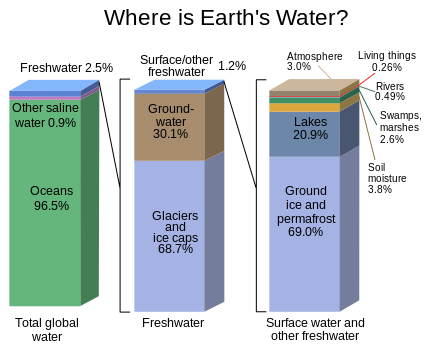
English: Graph of the locations of water on Earth |
| Πηγή | https://water.usgs.gov/edu/gallery/watercyclekids/earth-water-distribution.html - traced and redrawn from File:Earth's water distribution.gif |
| Δημιουργός | USGS |
| άλλες εκδόσεις | Earth's water distribution-gl.svg |
| SVG ανάπτυξη | Αυτή η διανυσματική εικόνα δημιουργήθηκε με Inkscape |
Αδειοδότηση
This image is in the public domain in the United States because it only contains materials that originally came from the United States Geological Survey, an agency of the United States Department of the Interior. For more information, see the official USGS copyright policy.
|
Ιστορικό αρχείου
Κλικάρετε σε μια ημερομηνία/ώρα για να δείτε το αρχείο όπως εμφανιζόταν εκείνη τη στιγμή.
| Ώρα/Ημερομ. | Μικρογραφία | Διαστάσεις | Χρήστης | Σχόλια | |
|---|---|---|---|---|---|
| τελευταία | 22:28, 31 Ιανουαρίου 2024 | | 430 × 350 (31 KB) | Asierog | spanish and french translations added |
| 12:32, 22 Νοεμβρίου 2016 |  | 430 × 350 (25 KB) | MaxxL | updated | |
| 14:00, 22 Μαΐου 2010 |  | 530 × 368 (202 KB) | Begoon | {{Information |Description={{en|1=Graph of the locations of water on Earth}} |Source=http://ga.water.usgs.gov/edu/waterdistribution.html |Author=USGS |Date= |Permission= |other_versions= }} |
Συνδέσεις αρχείου
Τα παρακάτω λήμματα συνδέουν σε αυτό το αρχείο:
Καθολική χρήση αρχείου
Τα ακόλουθα άλλα wiki χρησιμοποιούν αυτό το αρχείο:
- Χρήση σε en.wikipedia.org
- Χρήση σε en.wikibooks.org
- Χρήση σε en.wikiversity.org
- Χρήση σε es.wikipedia.org
- Χρήση σε et.wikipedia.org
- Χρήση σε eu.wikipedia.org
- Χρήση σε fr.wikipedia.org
- Χρήση σε gu.wikipedia.org
- Χρήση σε hi.wikipedia.org
- Χρήση σε hy.wikipedia.org
- Χρήση σε ka.wikipedia.org
- Χρήση σε ms.wikipedia.org
- Χρήση σε si.wikipedia.org
- Χρήση σε te.wikipedia.org
- Χρήση σε tr.wikipedia.org
- Χρήση σε vi.wikipedia.org
- Χρήση σε zh.wikipedia.org