
Αρχείο:Deepwater Horizon oil spill - May 24, 2010.jpg

Εικόνα σε υψηλότερη ανάλυση (2.118 × 1.628 εικονοστοιχεία, μέγεθος αρχείου: 369 KB, τύπος MIME: image/jpeg)
|
|
Αυτό το αρχείο και η περιγραφή του προέρχονται από το Wikimedia Commons. Οι πληροφορίες από την σελίδα περιγραφής του εκεί εμφανίζονται παρακάτω. |
Σύνοψη
| Περιγραφή |
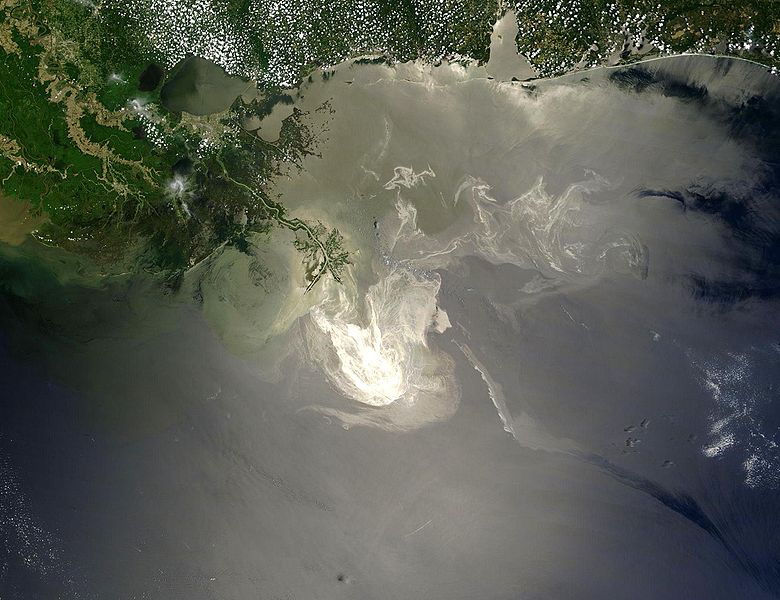
English: Description from NASA (source):
"NASA's Terra Satellites Sees Spill on May 24
Français : Traduction partielle de la description par la NASA(source): La marée noire causée par l'incendie de la plateforme pétrolière Deepwater Horizon vue par le satellite Terra, de la NASA, le 24 mai 2010.
Cette image a été acquise par le Moderate-Resolution Imaging Spectroradiometer (MODIS, pour Spectroradiomètre d'imagerie à résolution moyenne), embarqué sur le satellite Terra. Le pétrole lisse la surface de l'océan, ce qui la rend plus claire là où elle réfléchit le soleil (par exemple, au centre de la photo) et plus sombre ailleurs (par exemple en bas à droite). Le delta du Mississippi est visible en haut, entouré d'eaux saumâtres et boueuses qui apparaissent en brun, rayé de rubans argentés de pétrole. |
| Ημερομηνία | |
| Πηγή | Original image, here cropped on left and at top |
| Δημιουργός | NASA/GSFC, MODIS Rapid Response |
| άλλες εκδόσεις |
|

|

Αδειοδότηση
| Αυτό το αρχείο είναι κοινό κτήμα γιατί δημιουργήθηκε από την NASA. Η πολιτική πνευματικής ιδιοκτησίας της NASA δηλώνει ότι «Το υλικό της NASA δεν προστατεύεται από copyright εκτός αν αναφέρεται». (Σελίδα με την πολιτική πνευματικής ιδιοκτησίας της NASA ή Πολιτική Χρήσης Εικόνων του JPL). | ||
 |
Προσοχή:
|
Ιστορικό αρχείου
Κλικάρετε σε μια ημερομηνία/ώρα για να δείτε το αρχείο όπως εμφανιζόταν εκείνη τη στιγμή.
| Ώρα/Ημερομ. | Μικρογραφία | Διαστάσεις | Χρήστης | Σχόλια | |
|---|---|---|---|---|---|
| τελευταία | 05:26, 26 Μαΐου 2010 | | 2.118 × 1.628 (369 KB) | APK | == Summary == {{Information |Description={{en|"Sunlight illuminated the lingering oil slick off the Mississippi Delta on May 24, 2010. The Moderate Resolution Imaging Spectroradiometer (MODIS) on NASA’s Terra satellit |
Συνδέσεις αρχείου
Τα παρακάτω λήμματα συνδέουν σε αυτό το αρχείο:
Καθολική χρήση αρχείου
Τα ακόλουθα άλλα wiki χρησιμοποιούν αυτό το αρχείο:
- Χρήση σε af.wikipedia.org
- Χρήση σε be.wikipedia.org
- Χρήση σε ca.wikipedia.org
- Χρήση σε cs.wikipedia.org
- Χρήση σε da.wikipedia.org
- Χρήση σε de.wikipedia.org
- Χρήση σε en.wikipedia.org
- Marine conservation
- Portal:Marine life
- Wikipedia:Featured pictures/Space/Looking back
- Wikipedia:Featured picture candidates/delist/2010
- Wikipedia:Featured pictures thumbs/23
- Wikipedia:Featured picture candidates/June-2010
- Wikipedia:ITN archives/2010/May
- Talk:Deepwater Horizon oil spill/Archive 4
- Wikipedia:Featured picture candidates/Deepwater Horizon oil spill - May 24, 2010.jpg
- Wikipedia:Wikipedia Signpost/2010-06-28/Features and admins
- User talk:APK/Archive 22
- Wikipedia:Featured picture candidates/delist/Deepwater oil spill 5-24-10
- Talk:Deepwater Horizon oil spill/Archive 10
- Wikipedia:Picture of the day/April 2012
- Template:POTD/2012-04-20
- Wikipedia:Main Page history/2012 April 20
- User talk:APK/Archive 25
- Research and Development Institute of Ecology and the Sustainable Use of Natural Resources
- Wikipedia:Wikipedia Signpost/Single/2010-06-28
- Flash-gas (petroleum)
- Χρήση σε en.wikinews.org
- Χρήση σε et.wikipedia.org
- Χρήση σε fa.wikipedia.org
- Χρήση σε fr.wikibooks.org
- Χρήση σε he.wikipedia.org
- Χρήση σε hr.wikipedia.org
- Χρήση σε hu.wikinews.org
- Χρήση σε hy.wikipedia.org
- Χρήση σε lv.wikipedia.org
- Χρήση σε ms.wikipedia.org
- Χρήση σε nl.wikipedia.org
Δείτε περισσότερη καθολική χρήση αυτού του αρχείου.