
Αρχείο:Peru Quake Aug 15-2007.jpg

Μέγεθος αυτής της προεπισκόπησης: 509 × 600 εικονοστοιχεία . Άλλες αναλύσεις: 204 × 240 εικονοστοιχεία | 612 × 721 εικονοστοιχεία.
Εικόνα σε υψηλότερη ανάλυση (612 × 721 εικονοστοιχεία, μέγεθος αρχείου: 155 KB, τύπος MIME: image/jpeg)
|
|
Αυτό το αρχείο και η περιγραφή του προέρχονται από το Wikimedia Commons. Οι πληροφορίες από την σελίδα περιγραφής του εκεί εμφανίζονται παρακάτω. |
Σύνοψη
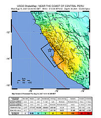
Image: Shake map of the magnitude 8.0 earthquake in Peru on August 15, 2007. Epicenter marked at star. Black box, placed by USGS, marks areas of Peru to be hardest hit.
Source: https://earthquake.usgs.gov/eqcenter/shakemap/global/shake/2007gbcv/
Αδειοδότηση
This image is in the public domain in the United States because it only contains materials that originally came from the United States Geological Survey, an agency of the United States Department of the Interior. For more information, see the official USGS copyright policy.
|

|
This map image could be re-created using vector graphics as an SVG file. This has several advantages; see Commons:Media for cleanup for more information. If an SVG form of this image is available, please upload it and afterwards replace this template with
{{vector version available|new image name}}.
It is recommended to name the SVG file “Peru Quake Aug 15-2007.svg”—then the template Vector version available (or Vva) does not need the new image name parameter. |


derivative works
Derivative works of this file: Peru Quake Aug 15-2007 cropped.jpg
Ιστορικό αρχείου
Κλικάρετε σε μια ημερομηνία/ώρα για να δείτε το αρχείο όπως εμφανιζόταν εκείνη τη στιγμή.
| Ώρα/Ημερομ. | Μικρογραφία | Διαστάσεις | Χρήστης | Σχόλια | |
|---|---|---|---|---|---|
| τελευταία | 20:25, 16 Αυγούστου 2007 | | 612 × 721 (155 KB) | DragonFire1024 | |
| 05:15, 16 Αυγούστου 2007 |  | 612 × 721 (156 KB) | DragonFire1024 | ||
| 00:56, 16 Αυγούστου 2007 |  | 612 × 721 (154 KB) | DragonFire1024 | '''Image:''' Shake map of the Peru earthquake on August 15, 2007. Epicenter marked at star. '''Source:''' http://earthquake.usgs.gov/eqcenter/shakemap/global/shake/2007gbcv/ |
Συνδέσεις αρχείου
Τα παρακάτω λήμματα συνδέουν σε αυτό το αρχείο:
Καθολική χρήση αρχείου
Τα ακόλουθα άλλα wiki χρησιμοποιούν αυτό το αρχείο:
- Χρήση σε ar.wikipedia.org
- Χρήση σε azb.wikipedia.org
- Χρήση σε bat-smg.wikipedia.org
- Χρήση σε be-tarask.wikipedia.org
- Χρήση σε be.wikipedia.org
- Χρήση σε bn.wikipedia.org
- Χρήση σε bs.wikipedia.org
- Χρήση σε cs.wikipedia.org
- Χρήση σε da.wikipedia.org
- Χρήση σε de.wikipedia.org
- Χρήση σε en.wikipedia.org
- Χρήση σε en.wikinews.org
- Χρήση σε es.wikinews.org
- Χρήση σε et.wikipedia.org
- Χρήση σε fi.wikipedia.org
- Χρήση σε fr.wikipedia.org
- Χρήση σε hi.wikipedia.org
- Χρήση σε id.wikipedia.org
- Χρήση σε it.wikipedia.org
- Χρήση σε it.wikinews.org
- Χρήση σε ja.wikipedia.org
- Χρήση σε ko.wikipedia.org
- Χρήση σε lv.wikipedia.org
- Χρήση σε mk.wikipedia.org
- Χρήση σε ml.wikipedia.org
- Χρήση σε ms.wikipedia.org
- Χρήση σε my.wikipedia.org
- Χρήση σε nah.wikipedia.org
- Χρήση σε ne.wikipedia.org
- Χρήση σε nn.wikipedia.org
- Χρήση σε no.wikipedia.org
Δείτε περισσότερη καθολική χρήση αυτού του αρχείου.