
Αρχείο:Habsburg Map 1547.jpg
Εικόνα σε υψηλότερη ανάλυση (1.654 × 1.029 εικονοστοιχεία, μέγεθος αρχείου: 534 KB, τύπος MIME: image/jpeg)
|
|
Αυτό το αρχείο και η περιγραφή του προέρχονται από το Wikimedia Commons. Οι πληροφορίες από την σελίδα περιγραφής του εκεί εμφανίζονται παρακάτω. |
Σύνοψη
| Περιγραφή |
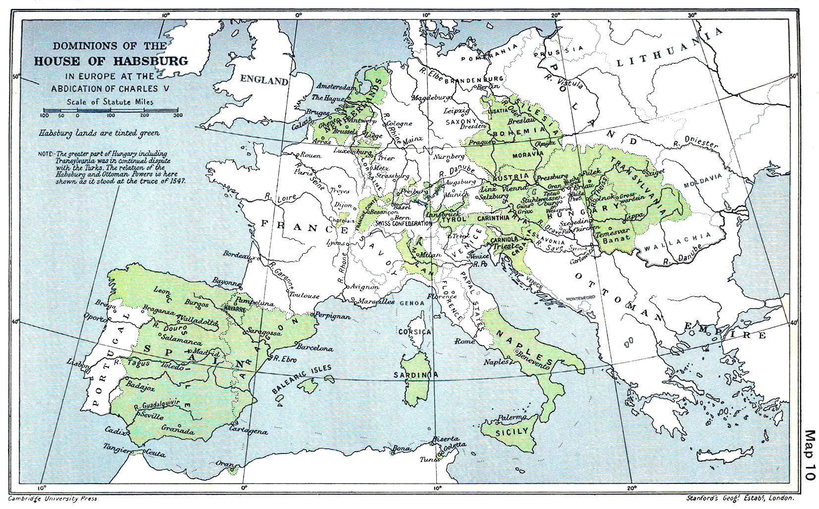
English: A map of the dominion of the Habsburgs following the Battle of Mühlberg (1547) |
| Ημερομηνία | |
| Πηγή |
The Cambridge Modern History Atlas, edited by Sir Adolphus William Ward, G.W. Prothero, Sir Stanley Mordaunt Leathes, and E.A. Benians. Cambridge University Press: London, 1912. Editors were Sir Adolphus William Ward (†1924), G.W. Prothero (†1922), and Sir Stanley Mordaunt Leathes (†1938). Individual authors of works making up the atlas are not identified, nor are the likely to be, after reasonable research. |
| Δημιουργός | edited by Sir Adolphus William Ward, G.W. Prothero, Sir Stanley Mordaunt Leathes |
| άλλες εκδόσεις |
|

Αδειοδότηση
Αυτό το έργο είναι κοινό κτήμα στις Ηνωμένες Πολιτείες επειδή δημοσιεύτηκε (ή καταχωρήθηκε στο U.S. Copyright Office) πριν την 1 Ιανουαρίου 1929.
Έργα που είναι κοινό κτήμα πρέπει να μην υπόκεινται σε πνευματικά δικαιώματα και στις Ηνωμένες Πολιτείες και στην χώρα προέλευσης του έργου για να φιλοξενηθούν στα Commons. Αν το έργο δεν είναι έργο από τις ΗΠΑ, το αρχείο πρέπει να έχει μια πρόσθετη ετικέτα πνευματικών δικαιωμάτων που να δείχνει το καθεστώς πνευματικών δικαιωμάτων του στην χώρα προέλευσης.
|
This UK artistic or literary work, of which the author is unknown and cannot be ascertained by reasonable enquiry, is in the public domain because it is one of the following:
|
 |
Ιστορικό αρχείου
Κλικάρετε σε μια ημερομηνία/ώρα για να δείτε το αρχείο όπως εμφανιζόταν εκείνη τη στιγμή.
| Ώρα/Ημερομ. | Μικρογραφία | Διαστάσεις | Χρήστης | Σχόλια | |
|---|---|---|---|---|---|
| τελευταία | 09:20, 29 Μαρτίου 2018 | | 1.654 × 1.029 (534 KB) | Trecătorul răcit | Little add: borders of the time |
| 11:01, 3 Σεπτεμβρίου 2015 |  | 1.654 × 1.029 (518 KB) | Kurzon | Reverted to version as of 17:22, 9 August 2010 | |
| 11:01, 3 Σεπτεμβρίου 2015 |  | 1.654 × 1.029 (518 KB) | Kurzon | Reverted to version as of 17:22, 9 August 2010 | |
| 21:33, 29 Ιουνίου 2013 |  | 1.654 × 1.029 (546 KB) | CSvBibra | add more contrast per request by another user | |
| 17:22, 9 Αυγούστου 2010 |  | 1.654 × 1.029 (518 KB) | CSvBibra | Previously put cleaned up version in new file with "b" after name. Now updating original file with "b" version. Both files uses throughout Wikipedias | |
| 09:07, 28 Αυγούστου 2008 |  | 1.654 × 1.029 (649 KB) | F l a n k e r | Wrap, shadows and minor improvements | |
| 14:42, 28 Ιουνίου 2005 |  | 1.654 × 1.029 (421 KB) | Rythin~commonswiki | A map of the dominion of the Habsburgs following the Battle of Mühlberg (1547). Taken from ''The Cambridge Modern History Atlas,'' edited by Sir Adolphus William Ward, G.W. Prothero, Sir Stanley Mordaunt Leathes, and E.A. Benians. Cambridge University Pr |
Συνδέσεις αρχείου
Τα παρακάτω λήμματα συνδέουν σε αυτό το αρχείο:
Καθολική χρήση αρχείου
Τα ακόλουθα άλλα wiki χρησιμοποιούν αυτό το αρχείο:
- Χρήση σε af.wikipedia.org
- Χρήση σε an.wikipedia.org
- Χρήση σε ar.wikipedia.org
- Χρήση σε arz.wikipedia.org
- Χρήση σε ast.wikipedia.org
- Χρήση σε azb.wikipedia.org
- Χρήση σε ba.wikipedia.org
- Χρήση σε be.wikipedia.org
- Χρήση σε bg.wikipedia.org
- Χρήση σε br.wikipedia.org
- Χρήση σε bs.wikipedia.org
- Χρήση σε ca.wikipedia.org
- Χρήση σε cs.wikipedia.org
- Χρήση σε da.wikipedia.org
- Χρήση σε de.wikipedia.org
- Χρήση σε en.wikipedia.org
Δείτε περισσότερη καθολική χρήση αυτού του αρχείου.