
Αρχείο:Globdisttornado.jpg
Μέγεθος αυτής της προεπισκόπησης: 800 × 429 εικονοστοιχεία . Άλλες αναλύσεις: 320 × 172 εικονοστοιχεία | 640 × 344 εικονοστοιχεία | 1.024 × 550 εικονοστοιχεία | 1.280 × 687 εικονοστοιχεία | 2.729 × 1.465 εικονοστοιχεία.
Εικόνα σε υψηλότερη ανάλυση (2.729 × 1.465 εικονοστοιχεία, μέγεθος αρχείου: 348 KB, τύπος MIME: image/jpeg)
|
|
Αυτό το αρχείο και η περιγραφή του προέρχονται από το Wikimedia Commons. Οι πληροφορίες από την σελίδα περιγραφής του εκεί εμφανίζονται παρακάτω. |

|
This map of the world image could be re-created using vector graphics as an SVG file. This has several advantages; see Commons:Media for cleanup for more information. If an SVG form of this image is available, please upload it and afterwards replace this template with
{{vector version available|new image name}}.
It is recommended to name the SVG file “Globdisttornado.svg”—then the template Vector version available (or Vva) does not need the new image name parameter. |


Σύνοψη
| Περιγραφή |
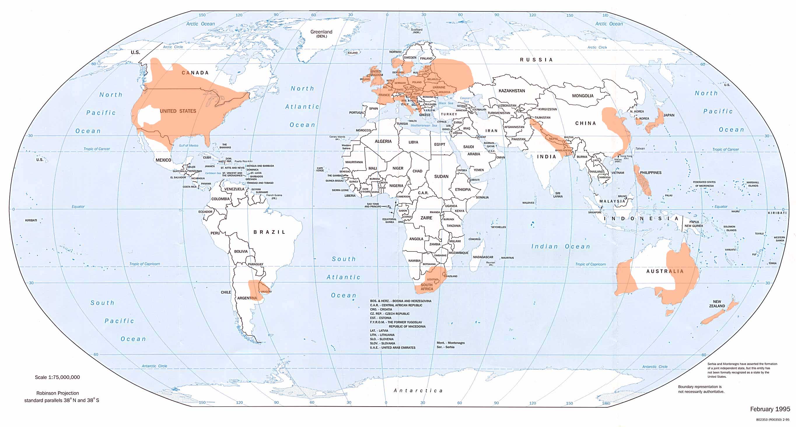
English: Shows where tornadoes are most likely to occur. From the website of the National Climatic Data Center, Asheville, North Carolina, USA. |
| Ημερομηνία | |
| Πηγή |
ncdc.noaa.gov/img/climate/research/tornado/globdist.jpg ncdc.noaa.gov/oa/climate/severeweather/tornadoes.html |
| Δημιουργός | National Oceanic and Atmospheric Administration (NOAA) |
Αδειοδότηση
This image is in the public domain because it contains materials that originally came from the U.S. National Oceanic and Atmospheric Administration, taken or made as part of an employee's official duties.
|
Ιστορικό αρχείου
Κλικάρετε σε μια ημερομηνία/ώρα για να δείτε το αρχείο όπως εμφανιζόταν εκείνη τη στιγμή.
| Ώρα/Ημερομ. | Μικρογραφία | Διαστάσεις | Χρήστης | Σχόλια | |
|---|---|---|---|---|---|
| τελευταία | 20:22, 13 Μαρτίου 2008 | | 2.729 × 1.465 (348 KB) | Runningonbrains | ==Summary== Shows where tornadoes are most likely to occur. From the website of the National Climatic Data, Asheville, North Carolina, http://www.ncdc.noaa.gov/oa/climate/severeweather/tornadoes.html Image location: http://www.ncdc.noa |
Συνδέσεις αρχείου
Τα παρακάτω λήμματα συνδέουν σε αυτό το αρχείο:
Καθολική χρήση αρχείου
Τα ακόλουθα άλλα wiki χρησιμοποιούν αυτό το αρχείο:
- Χρήση σε af.wikipedia.org
- Χρήση σε ast.wikipedia.org
- Χρήση σε ba.wikipedia.org
- Χρήση σε cs.wikipedia.org
- Χρήση σε en.wikipedia.org
- Χρήση σε en.wikibooks.org
- Χρήση σε es.wikipedia.org
- Χρήση σε fa.wikipedia.org
- Χρήση σε fr.wikipedia.org
- Χρήση σε gl.wikipedia.org
- Χρήση σε hu.wikipedia.org
- Χρήση σε id.wikipedia.org
- Χρήση σε it.wikipedia.org
- Χρήση σε ja.wikipedia.org
- Χρήση σε ko.wikipedia.org
- Χρήση σε lv.wikipedia.org
- Χρήση σε pl.wikipedia.org
- Χρήση σε ru.wikipedia.org
- Χρήση σε smn.wikipedia.org
- Χρήση σε uk.wikipedia.org