
Αρχείο:Virginia Ancestries by County no text.svg

Το μέγεθος αυτής της PNG προεπισκόπησης αυτού του SVG το αρχείο: 666 × 307 εικονοστοιχεία. Άλλες αναλύσεις: 320 × 148 εικονοστοιχεία | 640 × 295 εικονοστοιχεία | 1.024 × 472 εικονοστοιχεία | 1.280 × 590 εικονοστοιχεία | 2.560 × 1.180 εικονοστοιχεία.
Εικόνα σε υψηλότερη ανάλυση (Αρχείο SVG, ονομαστικό μέγεθος 666 × 307 εικονοστοιχεία, μέγεθος αρχείου: 145 KB)
|
|
Αυτό το αρχείο και η περιγραφή του προέρχονται από το Wikimedia Commons. Οι πληροφορίες από την σελίδα περιγραφής του εκεί εμφανίζονται παρακάτω. |
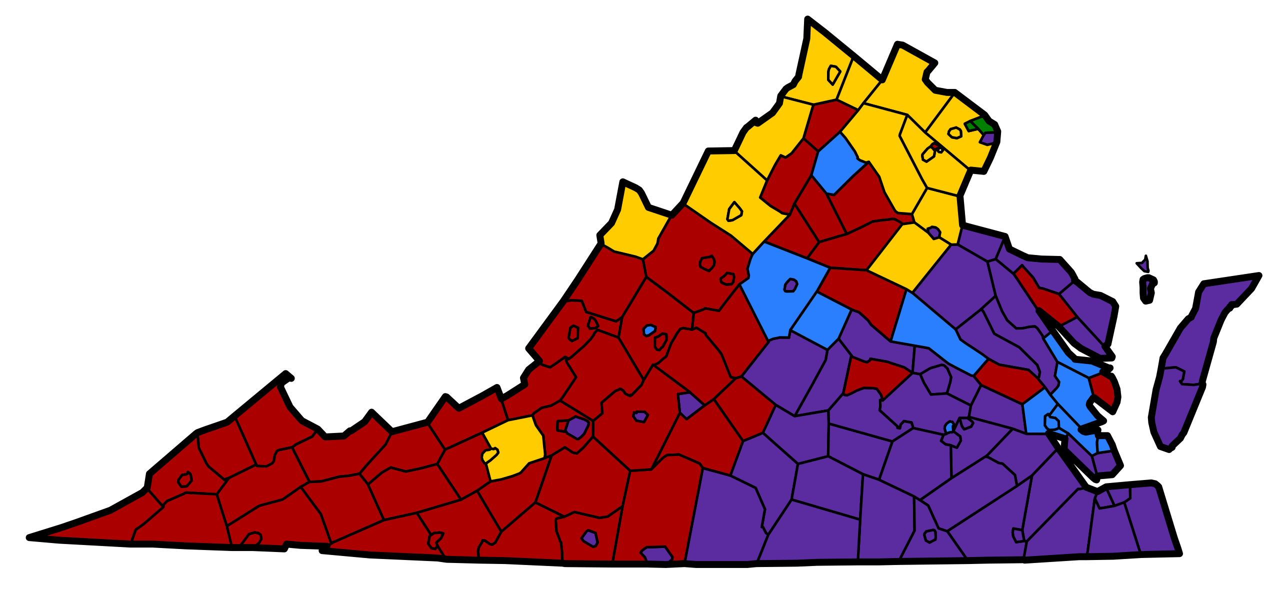
| Legend | |||||
|---|---|---|---|---|---|
| American | English | Irish | |||
| German | African American | ||||
| Περιγραφή | A map of the top reported ancestries in Virginia, as provided by the 2000 census. Shaded color represents the largest number of respondents (a plurality) from sample. Areas with the largest "American" ancestry populations were mostly settled by English, French, Welsh, Scottish and Irish. |
| Ημερομηνία | (UTC) |
| Πηγή | |
| Δημιουργός |
|
| άλλες εκδόσεις | JPG Version in English, SVG Version in English, JPG version in Spanish |
.svg)
| Αυτή είναι μία ρετουσαρισμένη εικόνα, που σημαίνει ότι έχει μεταβληθεί ψηφιακά από την αρχική της έκδοση. Τροποποιήσεις: Cropped to Virginia. Η πρωτότυπη μπορεί να βρεθεί εδώ: Census-2000-Data-Top-US-Ancestries-by-County.svg. Οι τροποποιήσεις έγιναν από τον Patrickneil.
|
This work is in the public domain in the United States because it is a work prepared by an officer or employee of the United States Government as part of that person’s official duties under the terms of Title 17, Chapter 1, Section 105 of the US Code.
Note: This only applies to original works of the Federal Government and not to the work of any individual U.S. state, territory, commonwealth, county, municipality, or any other subdivision. This template also does not apply to postage stamp designs published by the United States Postal Service since 1978. (See § 313.6(C)(1) of Compendium of U.S. Copyright Office Practices). It also does not apply to certain US coins; see The US Mint Terms of Use.
|
 | |
| Αυτό το αρχείο έχει χαρακτηριστεί ως απαλλαγμένο από γνωστούς περιορισμούς βάσει της νομοθεσίας περί πνευματικής ιδιοκτησίας, περιλαμβανομένων όλων των συναφών και συγγενικών δικαιωμάτων. | ||
Καταγραφές ανεβασμάτων πρωτότυπου αρχείου
This image is a derivative work of the following images:
- File:Census-2000-Data-Top-US-Ancestries-by-County.svg licensed with PD-USGov
- 2007-10-10T11:48:09Z Conscious 666x490 (3169790 Bytes) cropped
- 2007-03-09T15:44:05Z Gpvos 727x539 (2953361 Bytes) oops, fixed some reintroduced errors...
- 2007-03-09T15:32:46Z Gpvos 727x539 (2956252 Bytes) minor correction of text layout
- 2007-03-09T14:52:12Z Gpvos 727x539 (2953193 Bytes) now with text instead of font outlines
- 2007-03-09T14:25:16Z Gpvos 727x539 (3321809 Bytes) A chart of the top reported ancestries in the US, as provided by the 2000 census. Shaded color represents the largest number of respondents (a plurality) from sample. Areas with the largest "American" ancestry populations wer
Uploaded with derivativeFX
Ιστορικό αρχείου
Κλικάρετε σε μια ημερομηνία/ώρα για να δείτε το αρχείο όπως εμφανιζόταν εκείνη τη στιγμή.
| Ώρα/Ημερομ. | Μικρογραφία | Διαστάσεις | Χρήστης | Σχόλια | |
|---|---|---|---|---|---|
| τελευταία | 20:32, 23 Ιουλίου 2009 | | 666 × 307 (145 KB) | Patrickneil | light blue for English |
| 06:32, 7 Μαΐου 2009 |  | 666 × 307 (144 KB) | Patrickneil | narrower county borders | |
| 23:04, 27 Απριλίου 2009 |  | 666 × 307 (129 KB) | Patrickneil | Missed one | |
| 23:00, 27 Απριλίου 2009 |  | 666 × 307 (132 KB) | Patrickneil | changed colors since Virginia has 5 groups | |
| 20:45, 27 Απριλίου 2009 |  | 666 × 307 (127 KB) | Patrickneil | Half of Smith Island is Maryland | |
| 19:35, 27 Απριλίου 2009 |  | 666 × 307 (129 KB) | Patrickneil | {{Information |Description=A map of the top reported ancestries in Virginia, as provided by the 2000 census. Shaded color represents the largest number of respondents (a plurality) from sample. Areas with the largest "American" ancestry populations we |
Συνδέσεις αρχείου
Τα παρακάτω λήμματα συνδέουν σε αυτό το αρχείο:
Καθολική χρήση αρχείου
Τα ακόλουθα άλλα wiki χρησιμοποιούν αυτό το αρχείο:
- Χρήση σε zh.wikipedia.org