Αρχείο:Late Medieval Trade Routes.jpg
Τα περιεχόμενα της σελίδας δεν υποστηρίζονται σε άλλες γλώσσες.
Αυτό το αρχείο προέρχεται από το Wikimedia Commons
Από τη Βικιπαίδεια, την ελεύθερη εγκυκλοπαίδεια

Εικόνα σε υψηλότερη ανάλυση(1.457 × 1.088 εικονοστοιχεία, μέγεθος αρχείου: 372 KB, τύπος MIME: image/jpeg)

Σύνοψη

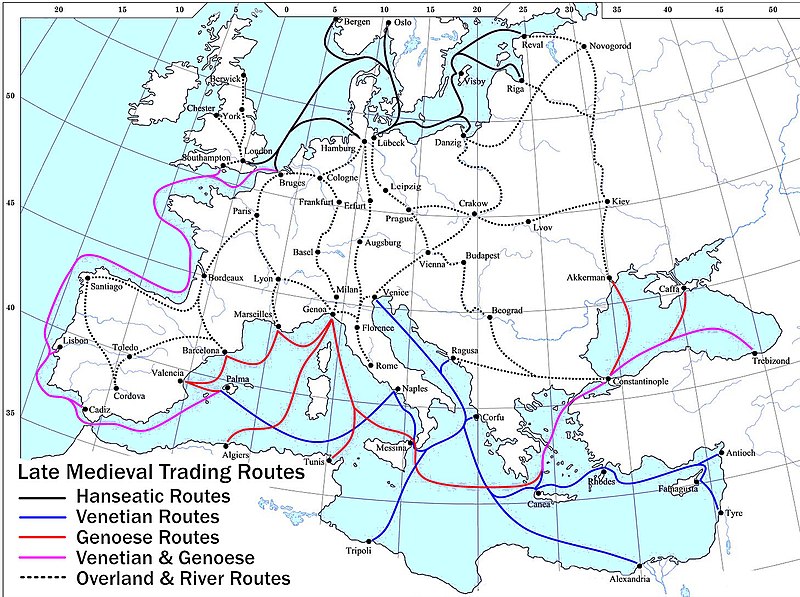
Περιγραφή Map showing the main trade routes of late medieval Europe. The black lines show the routes of the Hanseatic League, the blue Venetian and the red Genoese routes. Purple lines are routes used by both the Venetians and the Genoese. Overland and river routes are stippled.
Ημερομηνία
Πηγή Έργο αυτού που το ανεβάζει
Δημιουργός Lampman
άλλες εκδόσεις The map is based on this: , which in turn is based on an old, PD map. Magyar svg

Αδειοδότηση

Public domain Εγώ, ο κάτοχος των πνευματικών δικαιωμάτων αυτού του έργου, δημοσιεύω αυτό το έργο ως κοινό κτήμα. Αυτό ισχύει σε παγκόσμια κλίμακα.
Σε ορισμένες χώρες αυτό μπορεί να μην είναι νομικά εφικτό. Αν ναι:
Παραχωρώ σε οποιονδήποτε το δικαίωμα να χρησιμοποιήσει αυτό το έργο "για οποιονδήποτε σκοπό", χωρίς κανέναν όρο, εκτός και αν τέτοιοι όροι τίθενται από την νομοθεσία
Maps of the history of Europe
BCE
aC

Weichselian ice age (c. 113,000–9700) · Neolithic expansion (c. 7000–4500) · Middle Neolithic (c. 4500–4000) · Late Neolithic (c. 4000–3000) · Copper Age – Corded Ware culture (c. 2900–2350) · Copper Age – Bellbeaker culture (c. 2800–1800) · Early Bronze Age – Unetice culture (c. 2300–1600) · Late Bronze Age – Urnfield culture (c. 1300—750) · Migrations (c. 1000–100) · Hallstatt & La Tène cultures (c. 800–100) · Roman Republic (510–40) · 220 · 218 · 200 · 201–100 · 58 · 49 · 39 · 30 BCE–6 CE


CE
dC

14 · 14–37 · 60 · 60 · 69 · 80 · Migrations 100–500 · 117 · 117 · 125 · Migrations 150–774 · Economy 180 · 271 · 293–305 · 337 · 395 · c. 395 · 400 · 400 · 450 · 457–61 · 476 · 480 · Franks 481–814 · Early Slavs 500–700 · 500 · 526 · 526–600 · Christianisation to 600 · c. 550 · 650 · Pontic Steppe 650 · 665 · 800 · Vikings 800–1050 · 814 · 843–70 · 850 · 900 · 912 · 998 · 1000 · 1000 · 1054 · 1092 · First Crusade 1095–99 · 1097 · 1135 · 1142 · 1147–49 · 1190 · 1190 · 1250 · c. 1250 · 1301-1400 · 1301-1400 · 1328 · 1345 · Black Plague 1347–51 · 1360 · 1400 · Trade routes c. 1400 · 1430 · 1470 · 1490 · 1492 · 1500 · 1519 · 1550 · 1560 · Religion 1560 · Religion 1600 · Religion 1618 · 1618–48 · 1648 · 1683 · 1700 · 1701 · 1708 · 1714 · 1721 · 1725–30 · 1739–1740 · 1740 · 1748–66 · 1783–1792 · 1787 · 1787 · 1789 · 1799 · 1812 · 1812 · 1812 · 1812 · 1813 · 1815 · 1815 · 1815 · 1818 · Ottoman Empire 1830–1923 · 1848–49 · 1861 · 1867 · 1871 · 1878 · 1890 · 1905 · 1911 · 1914 · 1914 · 1919 · 1919–29 · 1923 · 1929 · 1930 · 1940 · 1941–42 · 1942–45 · Cold War 1947–91 · 1950 · 1993–2006 · 2006 to date

(this template: · view · discuss )

Λεζάντες

Δεν ορίστηκε λεζάντα

Items portrayed in this file

απεικονίζει

Ιστορικό αρχείου

Κλικάρετε σε μια ημερομηνία/ώρα για να δείτε το αρχείο όπως εμφανιζόταν εκείνη τη στιγμή.

Ώρα/Ημερομ.ΜικρογραφίαΔιαστάσειςΧρήστηςΣχόλια
τελευταία20:46, 18 Μαΐου 2022Μικρογραφία για την έκδοση της 20:46, 18 Μαΐου 20221.457 × 1.088 (372 KB)Richard2sClearer key for map
20:25, 23 Ιανουαρίου 2011Μικρογραφία για την έκδοση της 20:25, 23 Ιανουαρίου 2011853 × 544 (453 KB)Micsha~commonswikiIncludes map key on the map
15:55, 28 Μαρτίου 2008Μικρογραφία για την έκδοση της 15:55, 28 Μαρτίου 20081.817 × 1.120 (487 KB)Lampman{{Information |Description=Map showing the main trade routes of late medieval Europe. The black lines show the routes of the Hanseatic League, the blue Venetian and the red Genoese routes. Purple lines are routes used by both the Venetians and the Genoese

Τα παρακάτω λήμματα συνδέουν σε αυτό το αρχείο:

Καθολική χρήση αρχείου

Τα ακόλουθα άλλα wiki χρησιμοποιούν αυτό το αρχείο:

Δείτε περισσότερη καθολική χρήση αυτού του αρχείου.