
Αρχείο:IndoChina1886.jpg
Εικόνα σε υψηλότερη ανάλυση (1.573 × 2.079 εικονοστοιχεία, μέγεθος αρχείου: 875 KB, τύπος MIME: image/jpeg)
|
|
Αυτό το αρχείο και η περιγραφή του προέρχονται από το Wikimedia Commons. Οι πληροφορίες από την σελίδα περιγραφής του εκεί εμφανίζονται παρακάτω. |
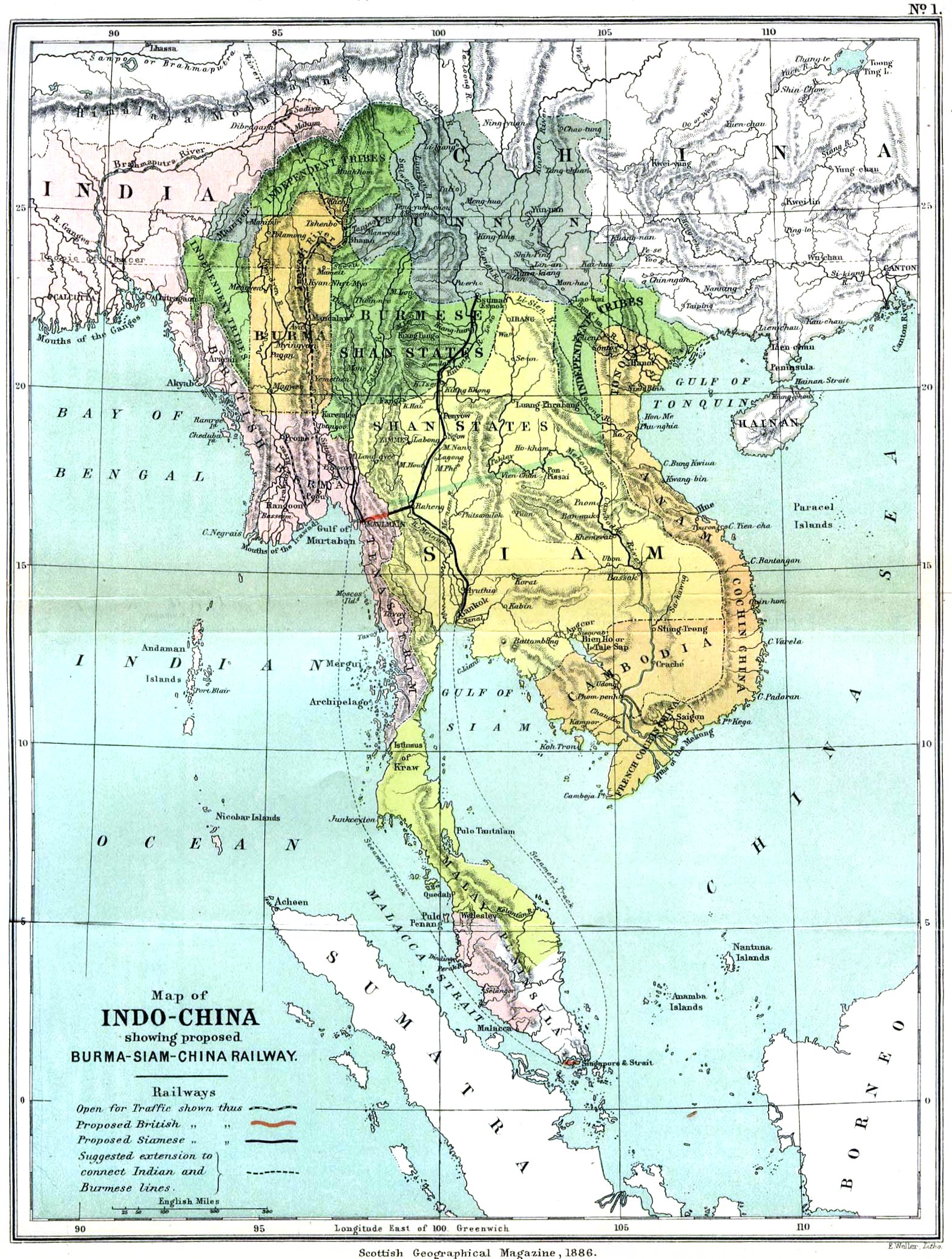
Source: Scottish Geographical Magazine, 1886
map of Indochina
Original version: File:Indochina map 1886.jpg
|
Αυτό το έργο είναι κοινό κτήμα στη χώρα προέλευσής του και άλλες χώρες και περιοχές όπου η διάρκεια πνευματικών δικαιωμάτων είναι όσο η ζωή του δημιουργού και μέχρι 70 χρόνια μετά ή λιγότερο.
| |
| Αυτό το αρχείο έχει χαρακτηριστεί ως απαλλαγμένο από γνωστούς περιορισμούς βάσει της νομοθεσίας περί πνευματικής ιδιοκτησίας, περιλαμβανομένων όλων των συναφών και συγγενικών δικαιωμάτων. | |
Ιστορικό αρχείου
Κλικάρετε σε μια ημερομηνία/ώρα για να δείτε το αρχείο όπως εμφανιζόταν εκείνη τη στιγμή.
| Ώρα/Ημερομ. | Μικρογραφία | Διαστάσεις | Χρήστης | Σχόλια | |
|---|---|---|---|---|---|
| τελευταία | 00:53, 21 Μαρτίου 2006 | | 1.573 × 2.079 (875 KB) | Julo | Indochina, map of 1886 {{PD-old}} category:Historical maps of Asiacategory:maps of 19th century |
Συνδέσεις αρχείου
Δεν υπάρχουν σελίδες που συνδέουν σε αυτό το αρχείο.
Καθολική χρήση αρχείου
Τα ακόλουθα άλλα wiki χρησιμοποιούν αυτό το αρχείο:
- Χρήση σε ace.wikipedia.org
- Χρήση σε af.wikipedia.org
- Χρήση σε anp.wikipedia.org
- Χρήση σε arz.wikipedia.org
- Χρήση σε az.wikipedia.org
- Χρήση σε be-tarask.wikipedia.org
- Χρήση σε be.wikipedia.org
- Χρήση σε bg.wikipedia.org
- Χρήση σε bn.wikipedia.org
- Χρήση σε br.wikipedia.org
- Χρήση σε bs.wikipedia.org
- Χρήση σε ca.wikipedia.org
- Χρήση σε cs.wikipedia.org
- Χρήση σε cv.wikipedia.org
- Χρήση σε cy.wikipedia.org
- Χρήση σε da.wikipedia.org
- Χρήση σε en.wikipedia.org
- Χρήση σε eo.wikipedia.org
- Χρήση σε es.wikipedia.org
- Χρήση σε et.wikipedia.org
- Χρήση σε fa.wikipedia.org
- Χρήση σε fr.wikipedia.org
- Χρήση σε fy.wikipedia.org
- Χρήση σε gl.wikipedia.org
- Χρήση σε gn.wikipedia.org
- Χρήση σε he.wikipedia.org
- Χρήση σε hi.wikipedia.org
- Χρήση σε hr.wikipedia.org
- Χρήση σε hu.wikipedia.org
- Χρήση σε hy.wikipedia.org
- Χρήση σε ilo.wikipedia.org
- Χρήση σε io.wikipedia.org
- Χρήση σε is.wikipedia.org
- Χρήση σε it.wikipedia.org
- Χρήση σε kk.wikipedia.org
Δείτε περισσότερη καθολική χρήση αυτού του αρχείου.