
Αρχείο:North america terrain 2003 map.jpg

Εικόνα σε υψηλότερη ανάλυση (3.300 × 2.938 εικονοστοιχεία, μέγεθος αρχείου: 1,66 MB, τύπος MIME: image/jpeg)
|
|
Αυτό το αρχείο και η περιγραφή του προέρχονται από το Wikimedia Commons. Οι πληροφορίες από την σελίδα περιγραφής του εκεί εμφανίζονται παρακάτω. |
|
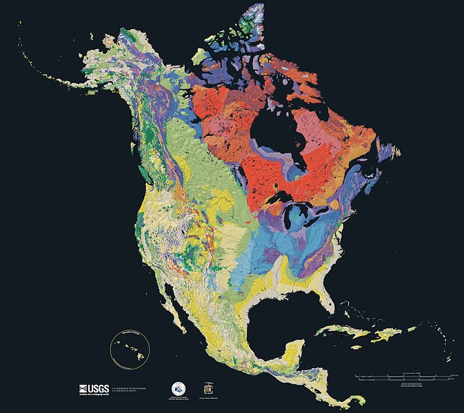
Relief map showing the varying age of bedrock underlying North America.

This cartographic tapestry is woven from a geologic map and a shaded relief image. This combination reveals the geologic history of North America through the interrelation of rock type, topography and time. Regional surface processes as well as continent-scale tectonic events are exposed in the three dimensions of space and the fourth dimension, geologic time.
From most recent to oldest, age is indicated by: yellow, green, blue, red.

The fuchsia U-shape of the Canadian Shield is clearly apparent. The base of ancient mountains and impact craters, this mineral-rich rock is nearly bare due to recent ice ages.

The Canadian Shield is an exposed part of the North American craton, a stable area which extends down the continent along the blue areas, and includes the sweep east of the Rocky Mountains back northward along the pale yellows of the Great Plains, light green across Wyoming and nearly to Alaska.
Rock types
Four maps show the North American distribution of four principal types of rock: sedimentary, volcanic, plutonic and metamorphic rock.


Source

The North America Tapestry of Time and Terrain (1:8,000,000 scale) is a product of the United States Geological Survey in the I-map series (I-2781). This map was prepared in collaboration with the Geological Survey of Canada and the Mexican Consejo Recursos de Minerales[1] archive copy at the Wayback Machine.
Home: http://pubs.usgs.gov/imap/i2781/
Image: http://pubs.usgs.gov/imap/i2781/i2781_c_low.pdf 144 dpi, encoded to 72 dpi JPEG, compressed slightly to fit within Wikipedia 2MB limit.
English Wikipedia, original upload 15 April 2005 by SEWilco
This image is in the public domain in the United States because it only contains materials that originally came from the United States Geological Survey, an agency of the United States Department of the Interior. For more information, see the official USGS copyright policy.
|
| Annotations | This image is annotated: View the annotations at Commons |
Ιστορικό αρχείου
Κλικάρετε σε μια ημερομηνία/ώρα για να δείτε το αρχείο όπως εμφανιζόταν εκείνη τη στιγμή.
| Ώρα/Ημερομ. | Μικρογραφία | Διαστάσεις | Χρήστης | Σχόλια | |
|---|---|---|---|---|---|
| τελευταία | 15:21, 16 Σεπτεμβρίου 2005 | | 3.300 × 2.938 (1,66 MB) | Saperaud~commonswiki | Relief map showing the varying age of bedrock underlying North America. thumb|150px|right|Time scale for [[:Image:North america terrain 2003 map.jpg|North America terrain ]] This cartographic t |
Συνδέσεις αρχείου
Τα παρακάτω λήμματα συνδέουν σε αυτό το αρχείο:
Καθολική χρήση αρχείου
Τα ακόλουθα άλλα wiki χρησιμοποιούν αυτό το αρχείο:
- Χρήση σε af.wikipedia.org
- Χρήση σε ar.wikipedia.org
- Χρήση σε arz.wikipedia.org
- Χρήση σε bn.wikipedia.org
- Χρήση σε de.wikipedia.org
- Χρήση σε en.wikipedia.org
- North America
- User:SEWilco
- Geologic map
- User:SEWilco/Images
- Wikipedia:Featured picture candidates/April-2005
- Wikipedia:Picture of the day/June 2005
- Wikipedia:Featured picture candidates/North america terrain 2003 map.jpg
- Wikipedia:Featured pictures thumbs/02
- Wikipedia:Wikipedia Signpost/2005-05-02/Features and admins
- Wikipedia:POTD/June 19, 2005
- Wikipedia:Picture of the day/June 19, 2005
- History of Earth
- User:Cyde/Featured pictures
- Portal:North America/Selected picture
- Portal:Maps/Selected picture
- Geography of North America
- User:Striver/Pictures
- Wikipedia:WikiProject Canada/Featured and good content
- Wikipedia:Picture of the day/April 2007
- Portal:Geology
- Template:POTD/2007-04-21
- Portal:Maps/Selected picture/15
- Wikipedia:Featured pictures/Diagrams, drawings, and maps/Maps
- Portal:Canada/Featured content
- Portal:Canada/Indices
- Portal:North America/Selected picture/19
- Geologic mapping of Georgia (U.S. state)
- Wikipedia:WikiProject United States/Recognized content
- Wikipedia:WikiProject United States/Quality content
- User:Avenue/sandbox
- Geology of North America
- Wikipedia talk:WikiProject Geology/Archive 3
- Talk:Geology of the United States/Archive 1
- Wikipedia:WikiProject United States/Featured pictures
- Portal:World
- Portal:Geology/Selected picture
- Wikipedia:Wikipedia Signpost/Single/2005-05-02
- User:Geothraner
- User talk:Geothraner
- Χρήση σε en.wikiquote.org
- Χρήση σε en.wikiversity.org
Δείτε περισσότερη καθολική χρήση αυτού του αρχείου.